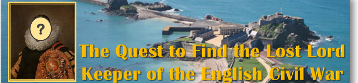
The unfolding historical research project to find the lost grave and legacy of England's remarkable "Lost Lord Keeper" of the 1600s English Civil War : Sir Richard Lane!
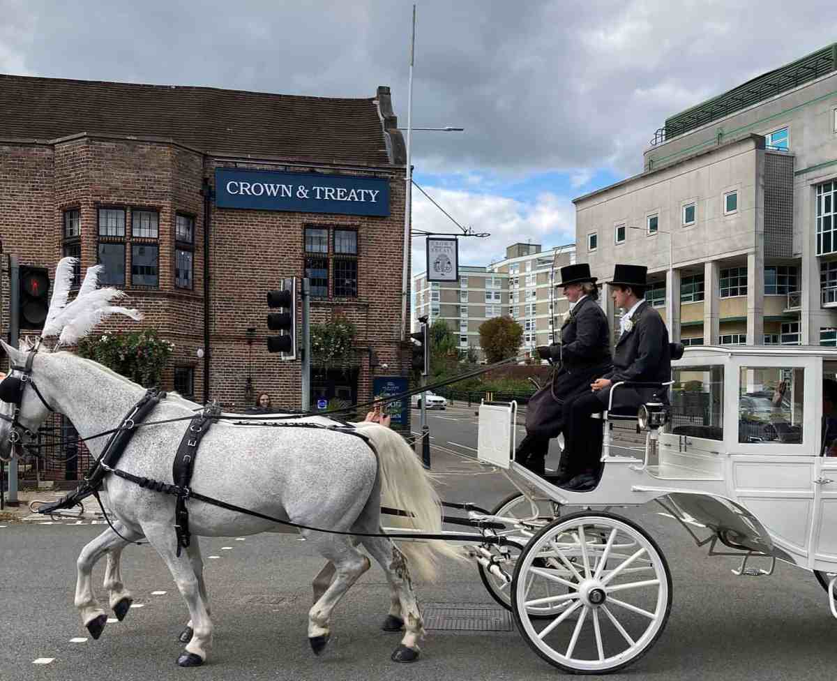
Especially to my friends in the UK, if you will be in London on Monday November 6, or on Saturday, November 11, I would love to see you at one of these talks in Uxbridge! I will be giving two talks, and unveiling an artwork based on my research that will hang in the main area of this beautiful historic (class II* listed site) pub, restaurant and venue in Uxbridge!
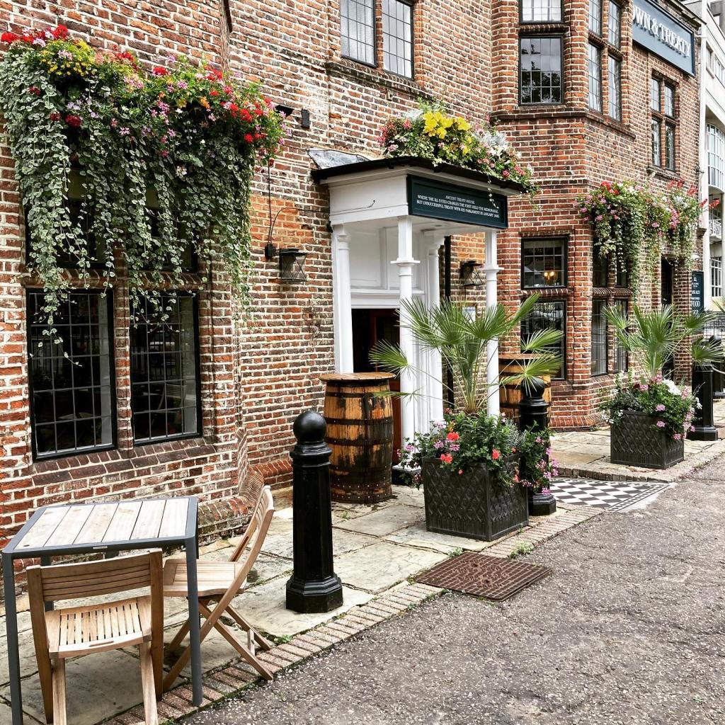
Especially to my friends in the UK, if you will be in London on Monday November 6, or on Saturday, November 11 (details below), I would love to see you at one of these talks in Uxbridge! Much of my time in the several years since our last trip to the UK has been spent working on the subject of my last few posts–a lovely class II* listed site in Uxbridge now known as the “Crown and Treaty”.
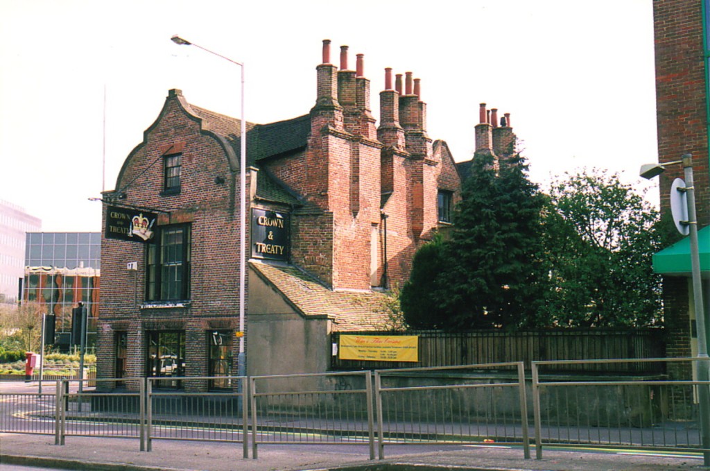
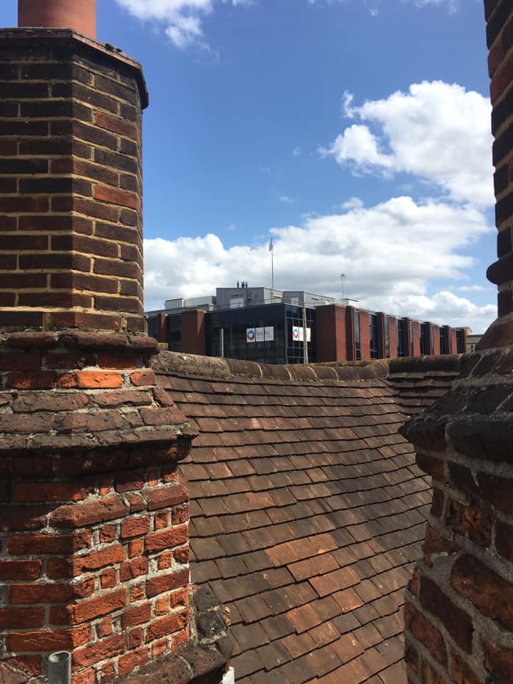
This view shows the remarkable chimney “turrets” that are one of the building’s most famous architectural features.
As has happened several times, I stumbled into a mystery about this building while researching a thread about Sir Richard Lane. Built in 1576, this remarkable house was originally far grander than even the surviving building would suggest. Despite being an important historic site after the 1645 Peace Treaty Negotiations were held there (during the English Civil War), the original property fell into disrepair and was largely torn down to make way for an important London canal project in the 1750s.
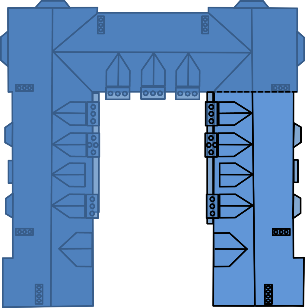
This is an overhead view of my “reconstruction model” of the Original Treaty house. The right wing is all that remains today.
Sadly, there are no surviving images of the original building and grounds. But while doing my other research, I came to realize there are a myriad of scattered clues about the original house: historical records and articles, accounts of the negotiations and the earliest depictions of the remaining structure made only a few decades after the rest of the house was demolished.
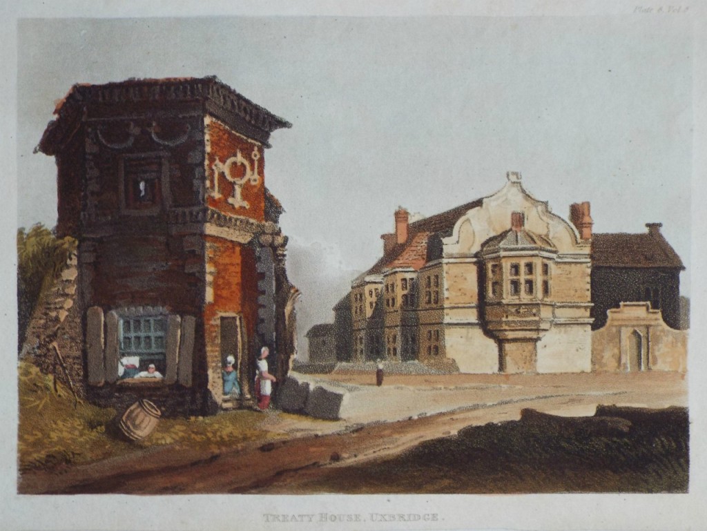
This historic watercolor is among the earliest depictions of the Treaty House (ca 1810) in the years following its first major renovation. In the foreground is the striking hexagonal gatehouse that was part of the original property.
Most tantalizing was that the vague reality those clues hinted at–the size of the building required to host the negotiations, and also how unique and grand this original property really was! So, I undertook an effort to build a virtual reconstruction of the original property. In the end, it came together!
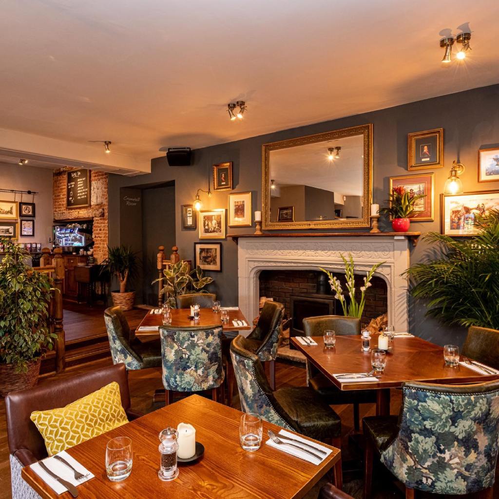
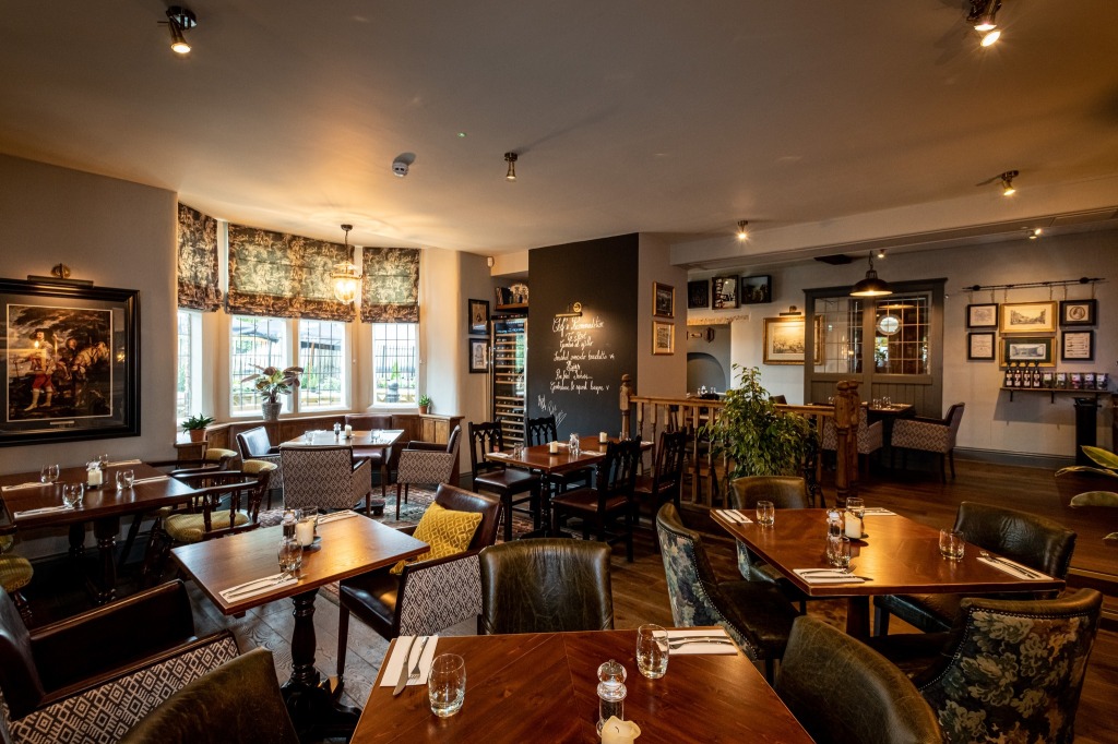
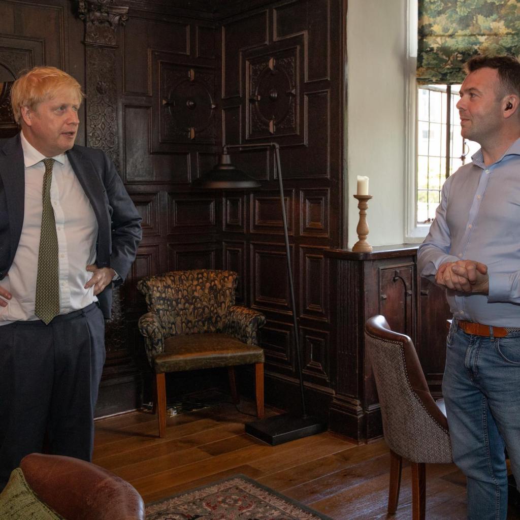
This scene is in the main seating area on the main floor. The “reconstruction” artwork will hang to the right of this fireplace.
So, with the help of an artist friend of mine, we will be unveiling a large picture of the Original Treaty House, framed with its story from my research. This large artwork will hang in the main floor next to a fireplace built while Queen Elizabeth I was in the middle of her reign. Having recently undergone a dramatic renovation by its most recent owners (the Old Spot Pub company), this site is now a beautifully done historic pub , restaurant, music spot and wedding/event venue. Truly an honor.
There are two talks: Both open to the public–please join us if you can!
The Jewel of Uxbridge: Unravelling the Lost Origins of the Crown and Treaty
— This talk will be oriented for the Uxbridge History Society, and so will focus a bit more on my research. It will include the first public view of a drawing of the Original Treaty house.
Monday, November 6, 2023 at 7pm
Church Hall of Our Lady of Lourdes and St Michael
Osborn Rd, Uxbridge UB8 1UE Uxbridge, UK (entrance to the hall is on the dual carriageway)
The Jewel of Uxbridge: Unveiling the Lost Origins of the Crown and Treaty
— This talk will be held upstairs in the room with the famous historic paneling and will be oriented more for the general public. It will include an unveiling of the “reconstruction” artwork created specifically to hang in this historic venue!
Saturday, November 11, 2023 at 3pm
Crown and Treaty
90 Oxford Rd, Uxbridge UB8 1LU Uxbridge, UK
After the talks in Uxbridge, I will post my last major article on the Crown and Treaty, and will include pictures from the talks, and (finally!) the picture of the Original Treaty House we have been working on for so long!
I am thrilled to thank my hosts for these talks, Sam (the General Manager of the Crown and Treaty) and Nick (Local History Society committee member and parish priest at Our Lady of Lourdes and St. Michael church). I am looking forward to meeting you both!
My final, deeply felt thanks go to the owners of the Old Spot Pub Company. Thank you so much for your significant investment in refurbishing this wonderful historic site. You have definitely restored some lovely shades of its original glory!
In its time, the original Treaty House and grounds were far more grand (and dominant) than what remains today would suggest. My research has led me to believe that to say that “the negotiations took place in a part of the house that has since been taken down” is much akin to presenting a single tire as a bicycle with some parts missing!
It was a jarring realization that the Uxbridge Treaty House is only a single surviving wing of a much grander original structure. This takes nothing away from the lovely existing building–it is a treasure, and feels complete on its own. But perhaps because it feels complete and seems to have always been perceived in variations of its current form, there remains little room to comprehend the true scale of the “fine house” and grounds that hosted the Peace Treaty Negotiations there in 1645. We can be forgiven having difficulty imagining it since (as we learned in my last article), among the mountain of images of his historic structure, not one of the original structure seems to have survived.
Crown and Treaty, Uxbridge. Photo credit Wikipedia.
To better understand the historic event that took place there over nearly a month, I shifted my focus to sweeping together all the bits of clues I’d found and creating the best model I could of the original house. To my surprise, I have been able to integrate these many shards into a remarkably cohesive and durable model, including a fair portion of its interior arrangements.
You see, in its time, the original Treaty House and grounds were far more grand (and dominant) than what remains today would suggest. My research has led me to believe that to say that “the negotiations took place in a part of the house that has since been taken down” is much akin to presenting a single tire as a bicycle with some parts missing!
The Mystery of the Original Treaty House
Perhaps the most useful aspect of my Uxbridge research has been reinforcement of the need to remain wary of falling in love with a particular theory. There are nearly always breadcrumbs of information to be discovered, but what should we make of them? However, even chasing a theory that ultimately proves incorrect can be very useful. Nearly every time I have found myself officiating the frustrated funeral of an beloved theory, I’ve found the effort to validate it has led me to compelling insights I wouldn’t have come to any other way.
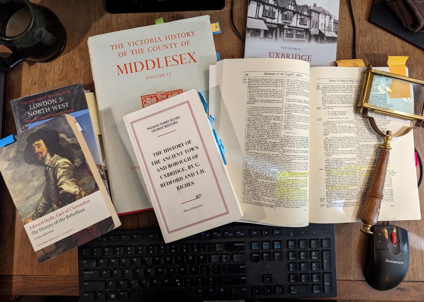
Although I do as much of my research online as possible, quite often I need to either borrow or buy books pointed to by footnotes to find the details I am looking for. My physical library has grown a whole new section of books related to my research into Uxbridge and the Treaty House.
My search for clues regarding the form of the original Treaty House led me to a few important sources. The first is a remarkable 1818 book of Uxbridge history called “The History of the Ancient Town and Borough of Uxbridge” by G. Redford and T.H. Riches. This wonderful work contains the most significant (and well substantiated) record of the history of the house I have found. Captured by period historians in the early 1800’s, this book also includes many fascinating notes about the state of the town at that time. Reading this book two hundred years later, these glimpses into the early 1800’s Uxbridge inhabited by its authors were as interesting as the excellent historical research that was the focus of their work!
From the Riches/Redford book I have gathered the following important points:
The original house was likely built sometime in the latter 1500’s (1576?). For much of its early history, this house was the seat of the Bennett family.
The original house “which was then considerably larger than at present [i.e. 1818], stood in the centre of a large garden. The high road now [in 1818], passes through nearly the middle of the grounds.” Note: other sources I have found indicate the surviving building was roughly 1/3 of the original structure.
The property was apparently partitioned in 1724.
Following the death of the last Bennett (Leonora, Lady Bennett) in 1638, the property went through a handful of owners over the next century. At the time of the treaty negotiations in 1645, it was the property of a “Mr. Carr”.
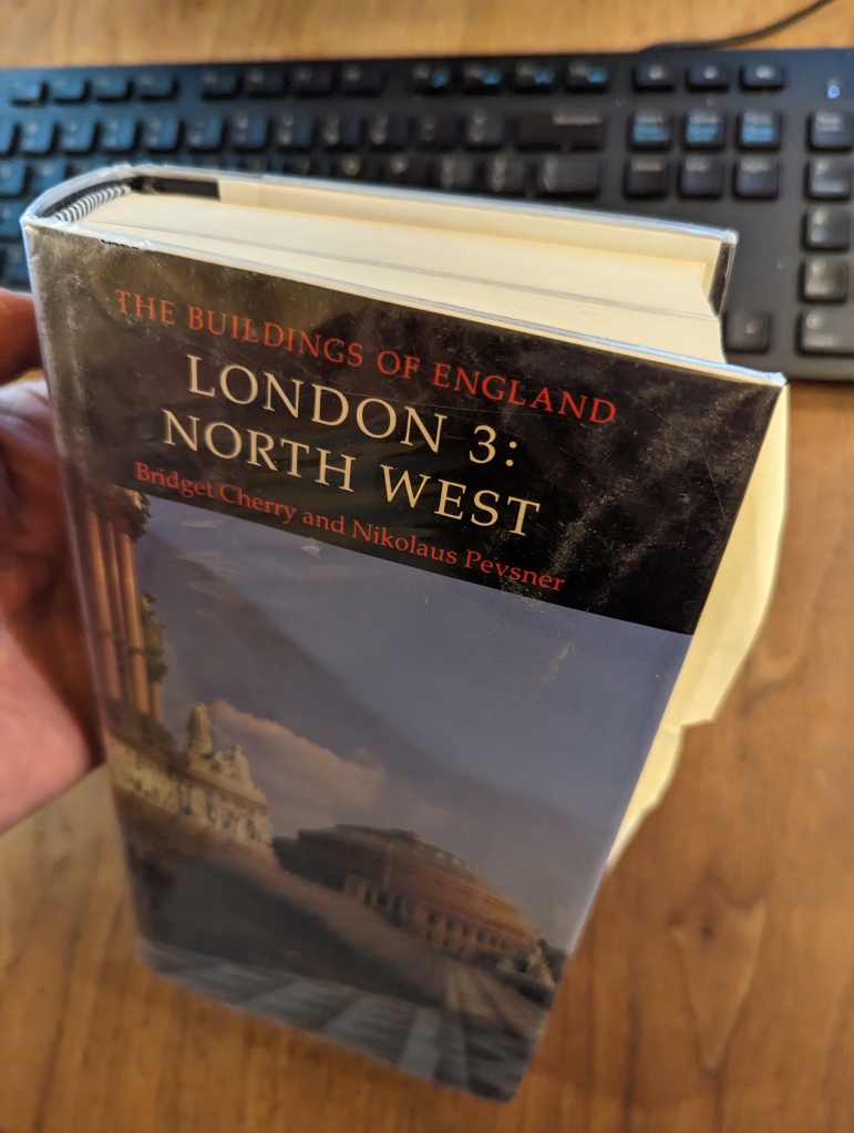
The second source of critical information I added to my collection is one volume of a carefully written set analyzing the architectural history of the buildings of England. This particular volume is titled “The Buildings of England, London 3: North West” (1991). Amidst a sea of elaborately developed details about innumerable other important historic buildings, this remarkable book distills a history and architectural analysis of the Crown & Treaty into a single, un-illustrated paragraph at the bottom of page 363. I found this tiny account while following up on an obscure footnote from a different, modern architectural publication.
This is the architectural history book that yielded the critical, singular clue about the layout of the original Treaty House.
I laugh to myself at having had to purchase a book that is more than an inch thick (containing 804 pages) to access a single blurb of information that would almost fit on a business card. But that concise little blurb was absolutely worth the trouble and expense! Among a number of other useful details, it contained a singular critical clue I needed about the layout of the original Treaty House.
And so, in a passage that could likely be read aloud in a few breaths, I found the following gems:
The Crown and Treaty was converted to an inn in 1802 after the property was purchased by the canal company to build a wharf for the Grand Canal. Note: the Grand Canal itself (which passes behind the Treaty House) was completed in 1793-4.
About the building’s history, the book states, “The present building consists of one wing of the formerly half-H shaped Treaty House…”
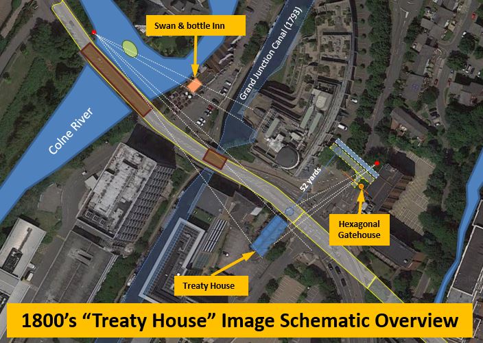
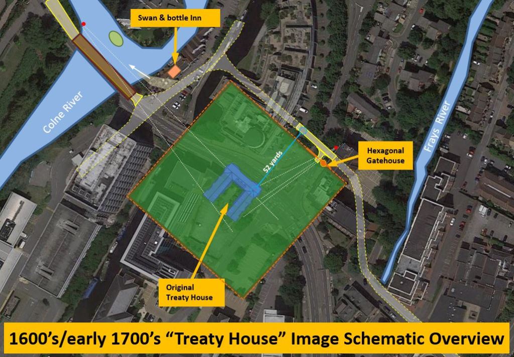
The rest of the building “was demolished in the 1750’s, and the road was later diverted across the forecourt.” From another source I learned the roadbed had been moved 52 yards from its original path.
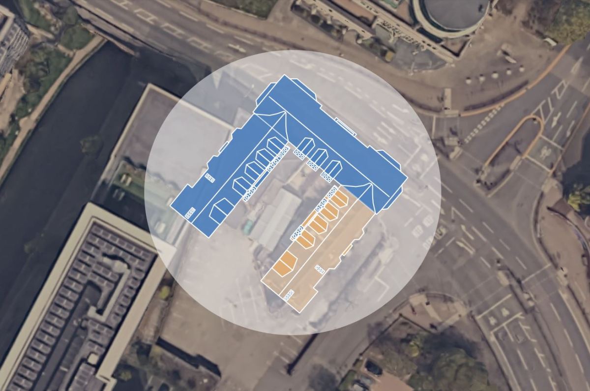
Overhead schematic view of the relocated Oxford Road and the existing Treaty House, showing the probable locations of artist renderings from the Colne River and the hexagonal gatehouse.
The third great resource I found was a book by John Rushworth which provides the following first hand account:
“This place being within the Parliament’s Quarters their Commissioners were the more civil and desirous to afford Accommodations to the King’s Commissioners, and they thought it fit to appoint Sir John Bennet’s House at the further end of the Town, to be fitted for the place of meeting for the Treaty.
The Fore-way into the House was appointed for the King’s Commissioners to come in at, and the Back-way for the Parliament’s Commissioners; in the middle of the House, was a fair great Chamber where they caused a large Table to be made like that heretofore in the Star-Chamber, almost square and without any upper or lower end of it. [note: another source indicates the negotiations room was on the upper floor].
The King’s Commissioners had one end and one side of the Table for them, the other side was for the Parliament’s Commissioners, and the end appointed for the Scots Commissioners to fit by themselves. Behind the Chair of the Commissioners on both sides sate the Divines and Secretaries, and such of the Commissioners as had not room to fit next to the Table.
At each end of the great Chamber was a fair Withdrawing-Room and Inner-Chamber, one for the King’s, and the other for the Parliament’s Commissioners to retire unto, and consult when they pleased.”
John Rushworth, ‘Historical Collections: The Treaty at Uxbridge, 1645
A Quick Aside: The Table at the “Star Chamber“
Rushworth’s observations about the negotiation table was a particularly valuable clue. A large square table had been custom made for the treaty negotiations. And, this table was “like that heretofore in the Star-Chamber”. But what does that mean? I think many of us have heard of the Star Chamber.
Aside from being a contender for the most intriguing name ever, the Star Chamber was both an actual room at Westminster Palace and also a colloquialism for the medieval “Court of Star Chamber” that gathered there. This infamous court is a tale of well-intentioned ideas gone horribly wrong. Conceived as as something like a Supreme Court, the Star Chamber served as a court of appeals from lower courts. It also had a second, very important purpose. Composed of a combination of privy councillors and senior judges of the common law, the Star Chamber was also charged with the task of hearing cases against those so powerful they were unlikely to ever be convicted by lower courts. The Star Chamber was an important step in the transition from the medieval to modern institutions of governance.
Lauded in its first few decades for its efficiency, flexibility and fairness, this special court was weaponized in the reign of Henry VIII as a tool of political oppression. Unfortunately, once begun, the abuse of this court’s power continued for more than a hundred years–well into the reign of King Charles I. The Court of Star Chamber was finally abolished by the rising parliament led by John Pym in 1641–one year before the start of the English Civil War.
John Pym was a busy man in 1641. Perhaps you remember him from my recent articles analyzing the “Trial of Strafford” painting that hangs in the House of Lords at Westminster? In that painting, Pym is depicted illuminated in mid-oration as he himself (successfully) weaponizes the House of Commons as an instrument of the assassination of a key supporter of King Charles I: the Earl of Strafford, Thomas Wentworth. Although Pym was the architect of the Parliament’s effort to wrest power of the government from the crown in the English Civil War, he was not among the parliamentary commissioners present at Uxbridge in 1645. He had died of illness a year before.
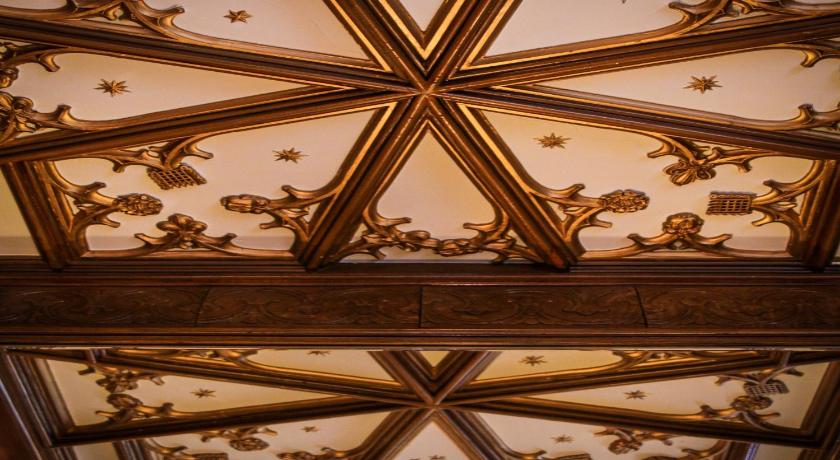
This image shows the famous Star Chamber ceiling now preserved (with a cream background instead of blue) at Leasowe Castle. Photo Credit: Leasowe Castle Hotel.
Ironically, the Rushford clue about the large square negotiating table at Uxbridge may be the only real clue about the original furnishing of the Star Chamber itself (except for the dark blue ceiling with ornate gold stars the chamber is named for). When the chamber was demolished in the early 1800’s the ceiling and tapestries were salvaged and taken to the Leasowe Castle on the coast of the Irish Sea near Liverpool. You can see this ceiling today if you stay at the Leasowe Castle Hotel!
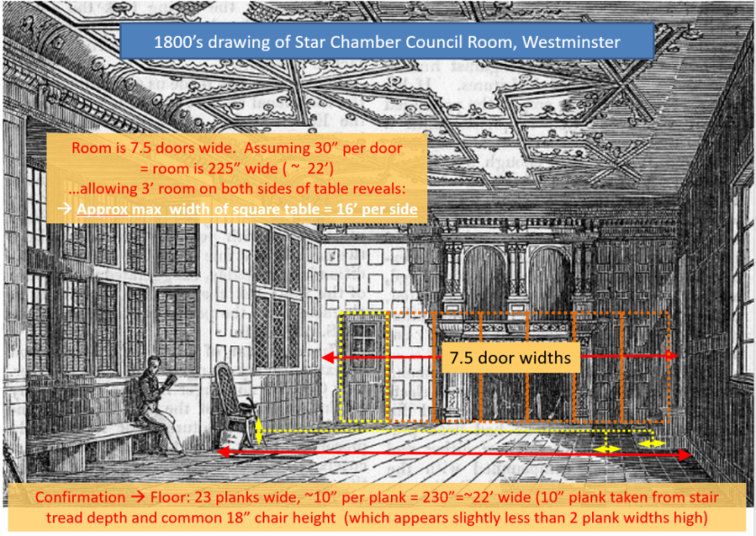
Looking at the drawing of the Star Chamber below, it seems that the room was rectangular, with the lesser dimension along the far wall. In this graphic, you can see the spatial analysis I used to estimate this room to be approximately 22 feet in width. Considering how large a table could occupy this space usably, I would estimate the table width could be as much as 16 feet on a side. Assuming humans have not dramatically changed their dimensions and allowing 2 feet per seated person, such a table would have seated as many as 8 people along each of its sides.
This is my spatial analysis of an image of the Star Chamber at Westminster and the table it once contained.
In Uxbridge, this would mean that roughly half of each side’s 32 commissioners (16 people) could have sat at the table, and at least this same number of seats behind the railings would have been required for the other half of the commissioners (and any other important attendees–the “Devines and Secretaries”). This is an important bit of information, as the size of this table and some idea of the minimum seating around it provides a defining bound on the minimum immediate space required to accommodate these negotiations.
First Model of the Original Layout of the Treaty House
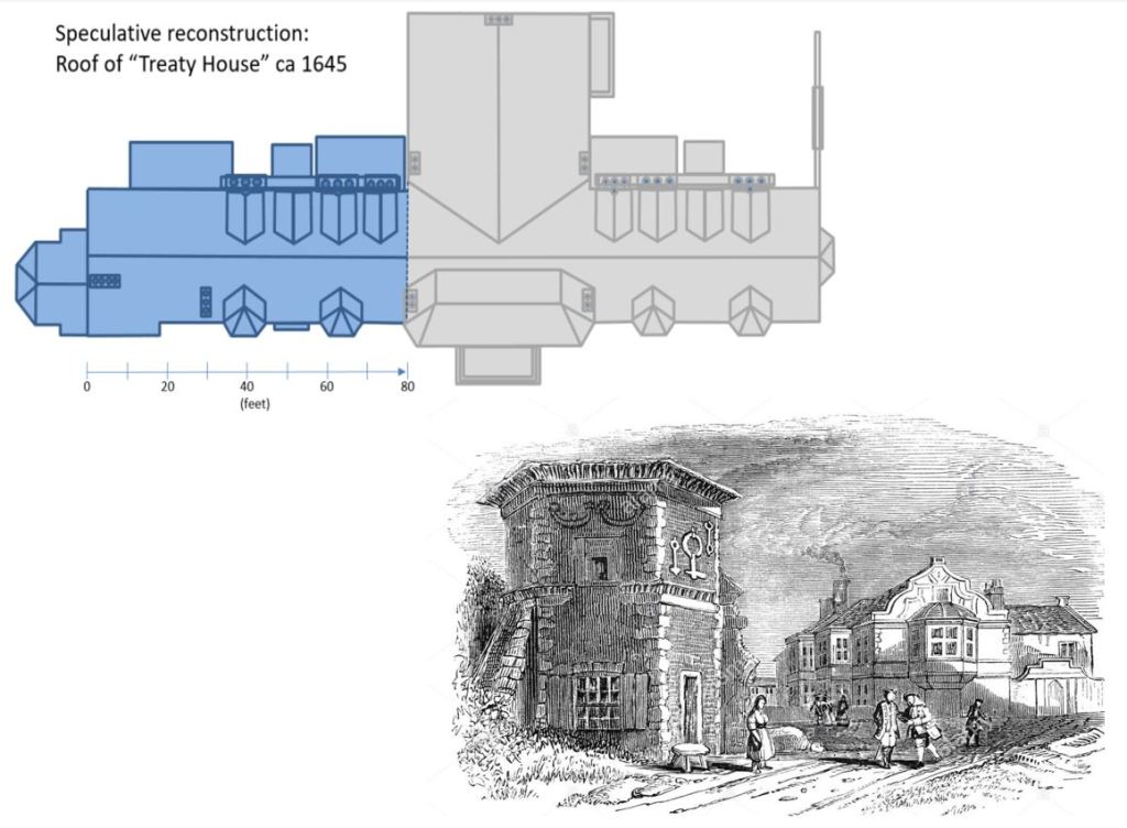
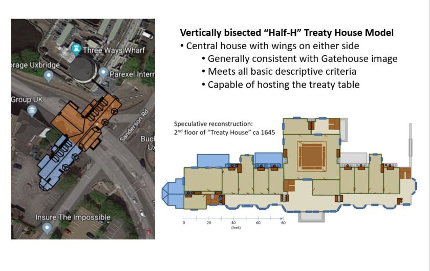
For awhile, I was convinced the “gatehouse” image discussed in my prior article could have been of the original Treaty House. Given that the original house was described as a “half H”, the question is: how do you split that “H”? Assuming it was split vertically, the wings would have been aligned along the same axis on either side of a center structure of the house (see the graphics of my first overhead model, below).
First model of the original Treaty House. In this model, the two wings would have oriented along the same axis along opposite sides of a central structure.
Under this assumption, the view from the gatehouse image would have been looking at the far end of the “other” wing, and the surviving wing of the structure would have been almost entirely hidden from view. In my second graphic, this overhead model is laid onto satellite imagery. From this overlaid image, it is apparent that this model certainly meets the criteria that the relocated Oxford Road passes “through the center” of the original house!
The second graphic reflects my modeling of the second floor of this version of the original building. The second wing is a mirror image of the existing wing. In the center section of the building, I continued the Elizabethan “gallery” along the front windows. I added fireplaces in reasonable locations to provide the ability to heat those spaces during cold weather. Given the size of what might have been originally conceived as a ballroom space, I added fireplaces in opposing walls for heating. Then, I identified reasonable stairwell locations and antechambers while leaving withdrawing spaces through which attendees could access the main chamber without interrupting discussions in the private chambers.
When doing such modeling, it is important to keep in mind that the model must make sense for the purposes such a building might have been originally designed to accommodate. Certainly, given its location in an inn-stop town along such an important road would have made it a good candidate for hosting official functions (such as circuit court proceedings, government meetings, etc). Also, hosting large entertainment events (such as balls or masques) would have had political benefits to the building’s owner. But perhaps more interesting to its architect would have been the prospect of creating a Middlesex venue that could host royal visits or other important events of state. Such an ambition would have been a natural motivation for the investments in the park-like grounds and attractive architecture of the building. The design of the gatehouse is far from merely functional–it was meant to impress! And if that had been part of architectural vision for this property, those investments had certainly paid off in 1645.
So how did this interior model feel? How well did it meet the criteria defined by the evidence I’d gathered? I gave it a solid maybe. It met the criteria, but the center building seemed a bit wide, raising concerns about how it could be supported structurally. The “withdrawing ” areas feel more cramped than implied, and narrowing the building would have made them even smaller. The original interior arrangement might have been like this, but it feels a bit forced.
Eventually, I determined there were two inescapable problems with this model. First, although the depiction details seem a bit “muddy” in the original version of the image I was working with, the left-facing protrusions in the image don’t quite align with the model. If the center of the house did not protrude beyond the primary wall of the wings, you would have seen all four bay windows of the wings in that line of sight. If it did protrude, the center section would have eclipsed the view of the two more distant bay columns, leaving three apparent protrusions from this viewpoint. The image only depicts two. In the end, I had to give the artist credit. This is an excellent depiction, and the artist that did it would not have gotten that detail wrong.
The second realization was a more definite discrepancy. In this arrangement, the face of the building nearest the artist in the gatehouse image would have been approximately 120 feet closer to the artist than the current, Oxford Road face is today (accounting for the width of the center section of the building and the length of the nearer wing combined). So, if the roadbed was moved 52 yards (or 156 feet) from its original location to its current location next to face of the surviving wing, the visible face of the original eastern wing would only have been about 40 feet from the original roadbed–which lay outside the wall. Of course, the nearest face of the building in the depiction is much further away than this.
My Second Model of the Original Treaty House
After I got a good sulk out of my system, my curiosity rose again, and I retrieved my frustration-flung papers from the floor. The vertically bisected layout was a non-starter. So what did that leave? It was time to reconsider the other way to interpret “half H” as the description of a shape. If the “H” were instead bisected horizontally, it produces a horseshoe-like shape. I had thought of this earlier, but had dismissed it as a non-intuitive way to describe this shape. But there really was no other remaining way to form a “half H”.
So I began work on my second reconstruction model, this time with two parallel wings joined by a center span at one end–forming a horizontally-bisected “half H”.
Overhead layout of my second model of the original Treaty House.
In this model, the two wings lie parallel to one another, and are mirror images of one another. Because the house was at the “center of a large garden”, the windows would have looked outward onto gardens from either wing. In this arrangement, the chimney sides of the two wings would have faced each other. Similarly, the center span would have also featured chimneys along its back wall and featured significant windows looking out over the portion of the gardens directly in front of the house.
Note that the center span could not have been at the other end of the wings. This would have formed the classic “E” arrangement where the front door lies within the arms of the wings. Also, in such an arrangement, the relocated Oxford Road would not have passed through the center of the original building.
The semi-enclosed space between the wings would have been interesting. The artful chimneys would have made it quite striking from the few windows available. But given the logistical realities of the time, I suspect this would have been a largely utilitarian space. At a minimum, it likely would have included wagon delivery parking and service doors for access to the kitchen and storage areas, a protected well for water and and protected storage for firewood.
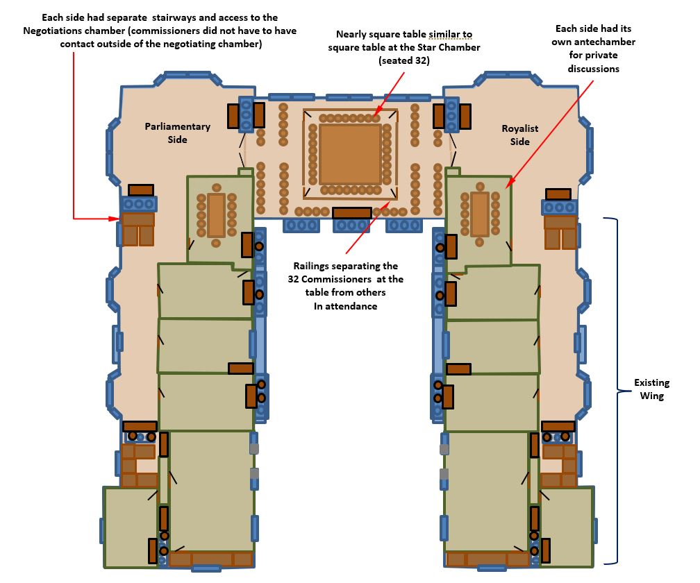
In the next graphic, you can see my interior model of the building. As indicated in the notes I’ve gathered, the negotiations chamber was in the center section of the building on the upper (second) floor, as illustrated.
The interior portion of my second reconstruction model of the original Treaty House.
In this model, the Royalist commissioners would have entered through the center door on the right (surviving) wing. Since it was closer to town this would have reasonably been described as the “Fore-way”. The parliamentary commissioners would have walked around the building and entered via the side door on the opposite wing (the “back-way”). Each would have turned toward the center of the building and ascended stairs to the second floor, where they could choose to enter their antechamber(s) or the large windowed “withdrawing room” for their side.
When ready to join the negotiations, the commissioners would pass through ornate double doors to enter the central “ballroom”. Arrangements of elegant chairs lined either side of a path to the central railing. Entering through gates in the railing, the commissioners made their way to their seats at the expansive table. Much as the mythical “round table” imagined by Chaucer for King Arthur and his knights, this brilliantly conceived table had no “head” and so placed all the commissioners on respectfully equal footing during these talks.
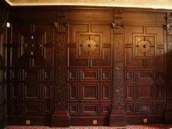
The ornate original panelling adorning the existing Treaty House today.
The surrounding walls of these spaces were likely fitted with the same famous rich panelling preserved in the surviving wing of the Treaty House. The walls were hung with many rich (likely official, state themed) tapestries to mark the occasion. Many-candled chandeliers above the table and sconces around the chamber provided most of the evening lighting, as the negotiations often did not end until after midnight. The rich, heavy drapes around the large windows were likely pulled closed as night fell, or as needed to trade away light for warmth during the bitter cold. When the drapes were open, the attendees could look out over the expansive gardens that lay between the house and high ornate wall standing more than 100 feet away. Within the chamber, the crackling of multiple fires provided islands of warmth to those gathered nearby.
Of course, there is some room for variance from this interior model, but perhaps not as much as you might think. With a gardens all around, and many windows facing them, the area nearest those windows would have generally been open in the Elizabethan gallery style. The pattern of fireplace placement with each room or space having at least one fireplace, plus orthogonally facing fireplaces at the boundaries of the large glassed in spaces) was taken from the existing structure and common practices with such galleries. The main “ballroom” would have been as large as possible, so this space would have been open completely between the outside walls (on the order of 30 feet wide).
Large closable doorways were probably situated between the central chamber and the large “withdrawing” areas on each side. This would have allowed flexibility in how the space was used. When open, these large doors would make the conjoined space space feel fairly continuous. When closed, such doors would allow the spaces to be isolated so they could be used separately and could be more effectively heated. Also, the wall structure such doors would have been built into was likely architecturally necessary to house fireplaces near the windows and load bearing columns to support the roof over such significant spans. Such columns needed to be placed somewhere, and the space in the middle of of the central room must have been unobstructed. Otherwise, it could not have accommodated the large table.
In my opinion, the most vulnerable details of this interior model are the placement of the stairs and the walls of the antechambers. For example, the staircases might reasonably have been located in the “withdrawing” areas and could have been implemented in any of several layouts. No matter where they were placed, these staircases would have been elegant. The more practical staff stairwells would have been located at the far end of the wings.
This overview of the grounds of the original Treaty House provides an estimate of the extent of its grounds. The famous gatehouse is included, but there certainly would have been additional gates.
The next graphic is my model of the estate itself. Although the boundaries of the property could easily have been any among a variety of irregular polygons, the building’s location mid-way between the beds of the Colne and Frays rivers and the hint of equidistance in the description of the house (lying “at the center” of a large gardens) led me to assume a roughly square boundary for the estate wall with its sides aligned to the walls of the existing structure. Of course, the size of this square was yielded by the fact that this estate was bisected by the road, which had been moved “52 yards” to align it with the bridges crossing the Colne and the Grand Junction Canal and then Mercer’s bridge across the Frays stream. Geometrically, this would have made the walled-in grounds approximately 300-350 feet on each side.
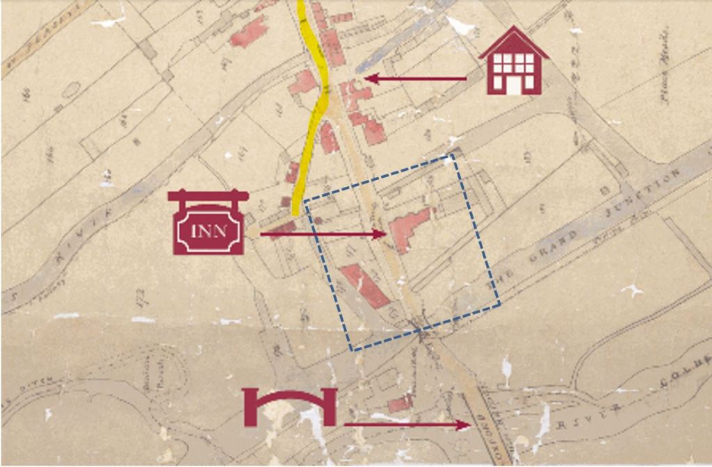
Recently, I got a gratifying confirmation of this speculation. I came across a pair of 1825 maps of Uxbridge showing road details and also the township boundaries. The first is a map (below) of the roadways and primary buildings present in Uxbridge at that time (1825). I have overlaid a properly scaled square of my estimated estate walls and registered it against the red outline of the Treaty House footprint at that time. In this map, there is a spur in the roadway from High Street just after it crosses the Frays stream. from High Street. This spur (which I believe was a vestige of the original bed of the Oxford Road, traces a path directly around the corner of my estimated estate wall!
Annotated detail view of an 1825 Map of Uxbridge in the collection of the Hillingdon Council. This view shows what appears to be a vestige of the original road around the Treaty House grounds, and even seems to show the location of the hexagonal gatehouse. Note: North is to the left.
Even more interesting–look closely at that corner of the property. Do you see that small red dot just inside the dotted line? I suspect this was the footprint of the hexagonal gatehouse, apparently still in existence at this time. Lying next to that gatehouse you can also see the end of a light blue canal leading back to the Grand Canal. If this scene seems familiar, it should. This is exactly the scene in the middle 1800’s gatehouse drawings which depict a canal passing directly in front of the elegantly dilapidated hexagonal gatehouse, with the surviving Treaty House building in the background.
One of several middle 1800s depictions of the hexagonal gatehouse in the foreground. Note the reinforced walls of the canal and the canal boat depicted passing by.
The next graphic is taken from a different 1825 map that illustrated the boundary of the Uxbridge township at that time. I had actually expected the property the Treaty House was built on to be much more elongated, extending to the South. I was a bit shocked to find the township boundary directly parallels the rear wall of the estate in my model of the grounds! This apparent extension of the township boundary (which otherwise lies to the east of the Frays stream) provides an interesting indicator of the footprint of the developed properties at that time.
Detail from an 1825 map of Hillingdon Parish that shows boundary of the Uxbridge township (which I have highlighted in yellow). Note this township boundary includes a rectangular shape that encompasses my estimated estate grounds of the original Treaty House.
To anyone who has ever owned and cared for horses for any period of time, leaving an apron of land beyond the walled-in part of the grounds wall makes perfect sense. Every time you “muck the stalls”, the cartload of horse manure and straw collected has to be dumped somewhere, and you would not want that inside the estate walls! Naturally, these estate walls would have included several utility gateways. Perhaps none was more utilized the one that would have been located near the outbuildings (and stables) at the rear of the walled-in estate. This “back-wall” gate would likely gotten significant use as manure carts, horses being grazed and wagons carrying firewood harvested from the commons passed through it.
That was a lot to cover, so if you made it this far, thanks for your interest in this work. Now, with the main course out of the way, it’s time for the dessert! In my next article, I will be presenting the wonderful, long sought image of the original Treaty House created by the talented artist helping me with this reconstruction.
It’s great to be writing again, and it will be wonderful to turn my attention back the queue of other articles that has been on hold for so long. I’m adding this section to my articles to share some of the other interesting things competing for my time. Most recently, this was our “bucket list” adventure at “Dry Tortugas”.
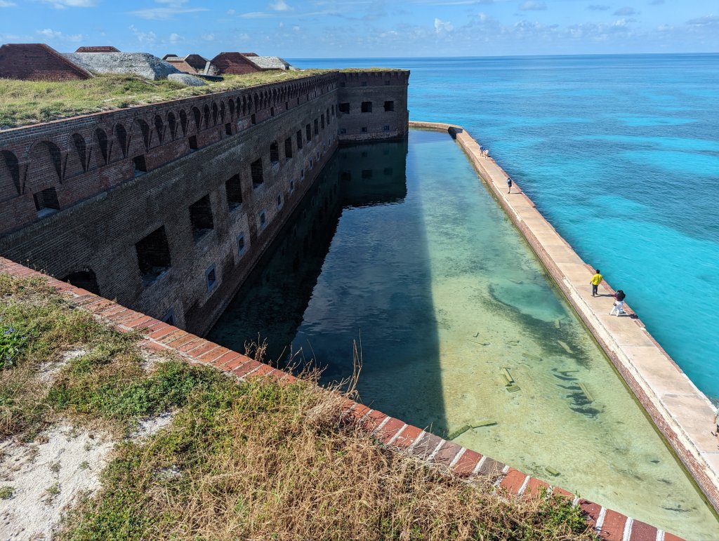
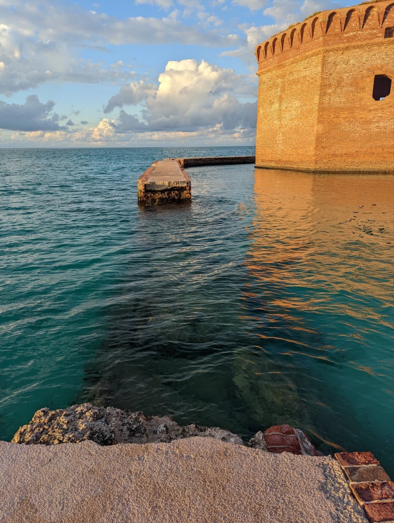
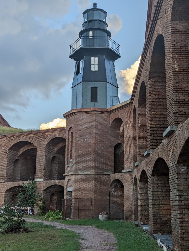
Dry Tortugas is America’s smallest national park. It is basically a large hexagonal brick fort from the 1700’s. This expansive fort almost completely covers a small spit of sand poking out of the Gulf of Mexico. fort Jefferson was a naval outpost built to support ships patrolling the gulf during the “golden age of pirates” of the late 1700’s. It lies 70 miles due West from Key West–the furthest island in the chain of “keys” at the very tip of Florida. A ferry boat makes a daily run to Dry Tortugas and provides the only services available there. Reservations on this ferry must generally be made a year in advance.
Along one side of the fortress walls there is a narrow strip of land you can camp on. After driving 2200 miles from Colorado (and dancing our way around hurricane Nicole) to get there, we camped and explored Dry Tortugas and a few neighboring keys for 3 fascinating days.
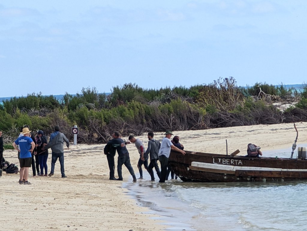
The unusual history and sea kayaking were as wonderful as we’d hoped, but we hadn’t expected to see migrant boats arriving from Cuba. It was moving. Nothing will make you appreciate what you have more than seeing someone fling themselves down to kiss the sand after a daring 100 mile open water crossing in an overcrowded, rickety boat–just for a chance of having it also…
The history of the Treaty House in Uxbridge was a story I was bursting to write, but just couldn’t bring myself to publish until I had what I needed to tell the story well. Originally, I expected it would only take a few weeks (maybe a month?) to do the research and get the story written. But that was much more than a year ago! This project has shown me just how stubborn I can be sometimes. But it has paid off…
If we were so misguided as to think of history as nothing more than a collection of dates, names and events, I wouldn’t describe it as merely uninteresting–I’d describe it as positively anesthetic! Why should we spend one minute of our own limited lives trying to understand the life of someone who already had their time under the sun? It’s a fair question. For me, the first answer is that I don’t believe anything is preordained. Quite often, whatever happened might have unfolded differently if some of the underlying factors had played out differently. Certainly, it’s not hard to imagine that the currently unfolding war in Ukraine would be going much differently if not for the unexpected solidarity and fighting spirit of the people and leaders of Ukraine.
My second reason is that generally, the “plays” of history are condensed into a general narrative focused on the primary actors and the outcomes of the “big picture”. Even if those narratives are entirely accurate, they seldom have the luxury of breathing life into the choices, character and outcomes of the lesser actors most of us would relate to. For me, grasping what it was really like in their time allows those long-dead actors to hold a mirror up for us to better understand ourselves and those around us. It allows the choices of those actors to provide lessons about the potential consequences of our own actions (or inactions). My favorite thought experiment is this: if we could travel through time and witness historical events like the Treaty Negotiations of 1645 for ourselves, how much of the scene would surprise us?
In the same way that my desire to have some idea what Sir Richard Lane looked like led me on a remarkable journey to find his lost portrait, my desire to comprehend the 1645 treaty negotiations through his eyes has led me to the mystery of the building that hosted those negotiations. And I discovered a surprise lurking in the details I found. The original Treaty House and its grounds were not just beautiful, they were grand. This property stood defiantly on one end of town, forcing the high road to Oxford to go around it. And to the royalist commissioners, it was outfitted by the peace faction of Parliament in hospitality and respect. It was provisioned in hope as thoroughly as it was in staples.
Despite how complete the existing Treaty House seems, historical records are clear that the building seen today was originally a much larger building. It’s also clear that the rest of that building was taken down long ago. Early on, I had hoped the room the negotiations took place in was still there. I would have loved to have stood in that space and imagined being there. It didn’t take long for me to discover this would not be possible, though. I soon found other records that make it clear that the negotiations room was in a part of the house that no longer exists.
Although disappointed, I was also hooked. I wanted to know more. I wanted to know what the original building was like. These negotiations were not some small meeting in the 1600’s equivalent of a corporate conference room. This event took months to plan, much more akin to a modern summit meeting in both size and importance. Each side of the negotiations was allowed 32 commissioners, but those accompanying the Royalist commissioners alone numbered around 180. The event lasted more than a month, requiring significant planning and care to decorate and provision the event for its participants. Try to imagine the scale of a room able to handle the large square table (approximately 16 feet on each side) that was built for the occasion. Then imagine there was space for a railing around it with additional seating beyond the railing.
What were the thoughts of Sir Richard Lane and his colleagues as they travelled that road into enemy held territory that cold January? How were they treated when they arrived ? Despite the well-documented hospitality of their parliamentarian hosts, feelings ran high on both sides of the argument. For their security, the commissioners were allowed to carry their swords for personal protection. And what was the sight that awaited them as they walked in groups from the Inns at the center of town?
The stakes could not have been higher. If the negotiations had been successful, much of the pain of that era might have been avoided. Imagine if there had been no exile of Charles II and no execution of King Charles I. What if there had been no Commonwealth era and and no need for a Restoration?
But the royalist commissioners were also working for a much more personal outcome–reaching an agreement was their best hope of wresting their careers, families and very lives from the nightmare scenario of having remained loyal to an increasingly lost cause. For Richard Lane, a successful treaty would have allowed him to return to London not merely as a senior Master of the Bench of Middle Temple, but as Chief Baron of the king’s Exchequer Court, and personal advisor to the next King of England. Sir Richard would have been a much-remarked upon figure in the post-war era. His thoughtful and well founded understanding of the law and governance would have marked him among the most widely respected figures of his time. He would have returned to his family and home in Northampton in great favor, influence and probably wealth.
But that’s the version of history that didn’t happen. The peace negotiations of 1645 were the tipping point for Sir Richard Lane’s personal fate, and they were not successful. The war resumed. His family home and possessions were confiscated by a vengeful Parliament. Only a year later, Lane participated in his next negotiations–for terms of surrender for the king’s wartime capital of Oxford. Afterwards, Sir Richard Lane was punished for his loyalty to the throne by being forced into exile with the king’s heir, Charles II. King Charles I was captured, and after years of resisting pressure to compromise the “divine right of kings”, he was executed. For years, Sir Richard Lane served the impoverished ascendant King Charles II in exile as counsellor and Lord Keeper of the Great Seal. He would eventually fall ill and die there, never having seen his family or his home again.
The 1645 Peace Treaty Negotiations were a happier tipping point for the mansion that hosted them. If not for its legacy of hosting one of the most important treaty negotiations in English history, the mansion previously known as the “Bennet House” would otherwise have been torn down in obscurity long ago.
The Search for the Original Treaty House
All I needed to tell the story of the Treaty Negotiations effectively was an image of the original mansion. If I could just locate one, I would wrap up the research, publish my article and move on to the next subject. It was easy enough to think so, but locating the image I needed soon became the deepest “rabbit hole” I’ve stumbled into yet!
The difficulty isn’t finding historic images of the Treaty House—there are many of them. If fact, those images tell a story of a building that has seen many uses, and has stood while many buildings around it rose and fell (including several buildings that were appended to the Treaty House itself at differing times). For a time, I thought I had even found the image I was after. But after months of studying, occasionally over-interpreting, and ultimately dismissing every image I could find, I realized something important: all of the surviving images of the Treaty House are of the existing building over time. It seems by the time even the oldest of these surviving images was created, living memory of the original structure had long since faded.
What has survived of the original house are a smattering of clues and descriptive mentions in various historical sources. I decided to see if I could leverage these clues to extend my speculative model of the original interior of the existing structure into a model of the entire original building. This was a time consuming but interesting exercise. Through a few iterations, it has yielded a compelling model that aligns well with the available evidence and architectural styles present in the existing building. Finally, with the help of a talented and historically inclined graphic artist, I now have the image I have sought: a remarkable sketch of the “reconstructed” Original Treaty House yielded by this model. And it is beautiful. I will share it in the next few articles, but we have some interesting ground to cover first.
Let’s start by unwinding a visual history of the Treaty House from modern times, through the Industrial age and backwards to the time of the middle 1600’s. Let’s get a sense of what has transpired since the time Sir Richard Lane and the other commissioners made their way through the spaces of what is now an elegant restaurant on their way upstairs to stop the war and save their king.
A Journey Backwards in Time with the Treaty House
The challenge with trying to understand the original form of a mansion that was built 300 years before the invention of photography is that buildings normally undergo changes over time. For instance, although the current structure is a natural and timeless brick construction, for most of modern history, the Treaty House was sheathed in a layer of white stucco. The brickwork was re-exposed sometime in the 1970s. The effort and care that must have taken is almost enough for me forgive the 70’s for disco…
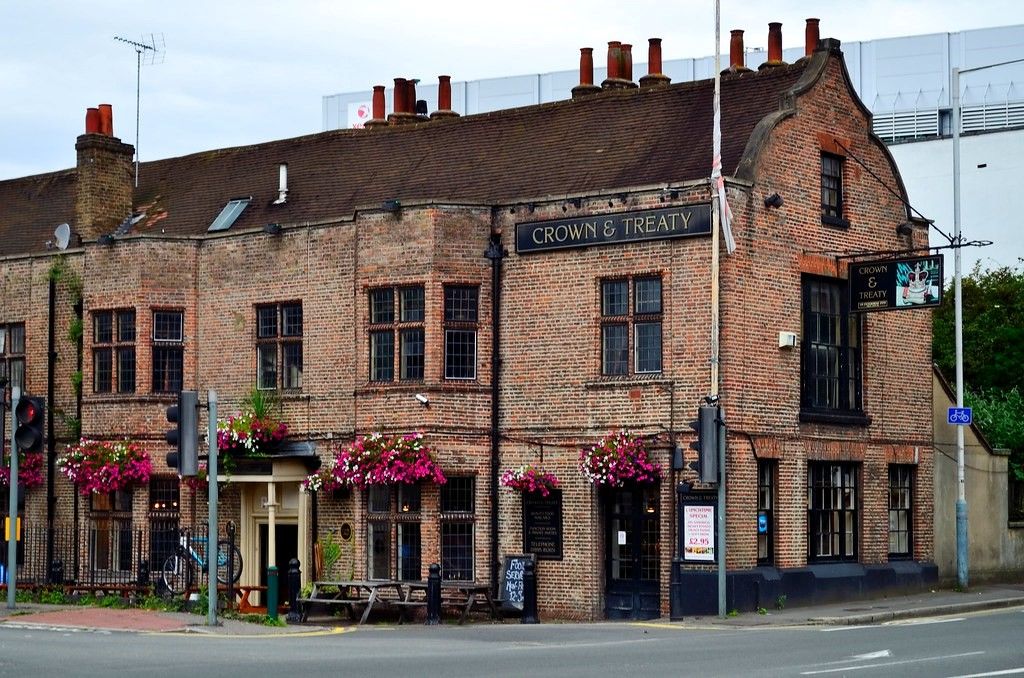
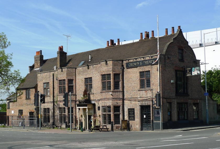
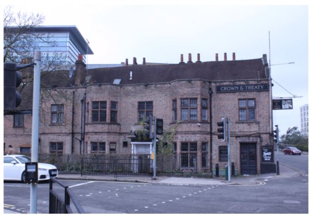
Modern street view of the Crown and Treaty (2018). The building sits at a major intersection in what can reasonably be described as a technology park.
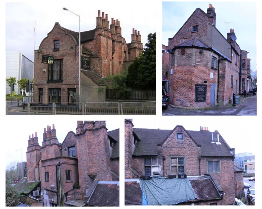
Additional modern views of the Crown and Treaty (2018) for reference, showing all faces of the building.
The Treaty House in the 1900’s
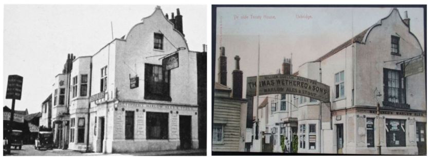
The next two images are photographs of the Treaty House from the early years of World War II. On the left is a photograph from 1937, and on the right, a colorized photograph from ca 1940. The most striking insights of these images are the closeness of the street alongside the building, the presence of an attached building along the face of the Oxford Road end of the building and the stucco covering the original brickwork. At the time, the main floor served as a retail establishment with the second floor used for living spaces. Note the presence of the second floor sign projecting over the Oxford Road calling attention to the structure’s historic role. An inspection of the modern images reveals that the this metal structure and an updated version of the sign survive to this day.
Photographs of the Treaty House in the pre-World War II era.
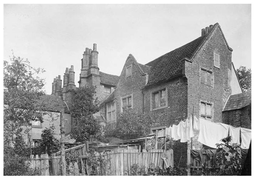
A unique photograph of the building from the early 1900s depicts the state of the rear of the building at that time. Its interesting to note that in the early 1900’s, the stuccoing had been removed from the non-street faces. This was a change. As you will see, the rear of the building was also also stuccoed in earlier times. The concrete structural repair to the upper floor wall at the right of this image. This concrete structural repair is still present today.
1903 photograph of the rear of the Treaty House
The Treaty House in the 1800’s
The time of the Industrial Revolution was also a time of great renaissance of historical interest in England. During this era (middle 1800’s), a great many historical articles were printed and accompanied by illustrations to support them. Thus, there are a number of interesting images of the Treaty House from this time. Some of these images are contemporary, while others were historical, based on older images.
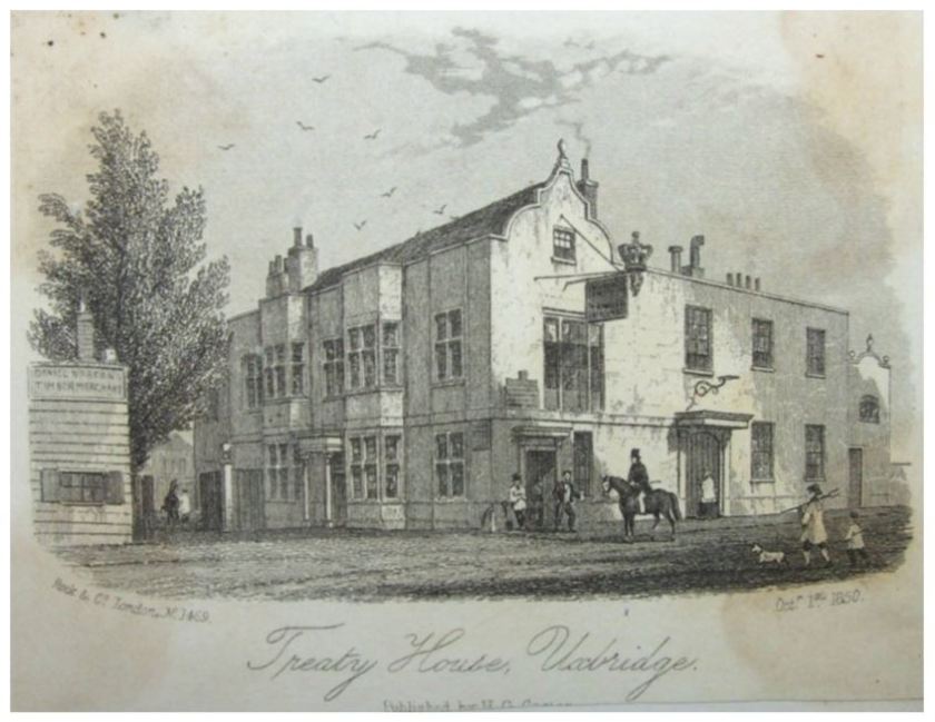
In the carefully made image of the Treaty house (below) dated 1850, you can see a full view of the building that had been joined to the side of the Treaty House facing onto the Oxford Road. Notice the changing door arrangements on the Oxford Road face of the Treaty House itself. This image also reveals the purpose of the horizontal loop at the end of the metal sign that still overhangs the road—it once held a large decorative crown.
At the time this 1850 image was made of the Treaty House, it was apparently still serving as an Inn. It had been adapted to this purpose during a major renovation in 1802.
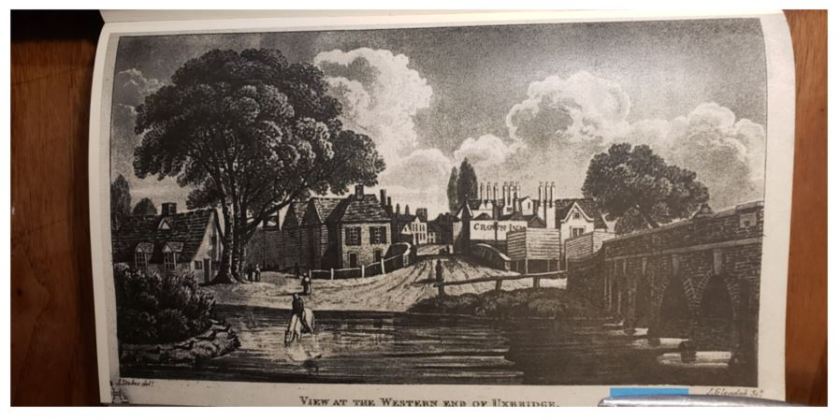
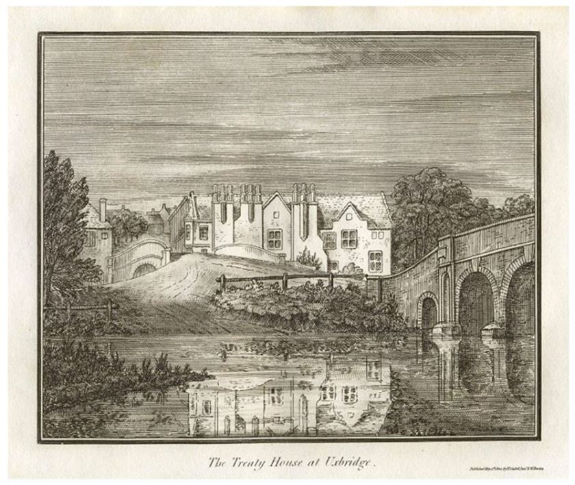
This next image is from the same general era. This view from the Colne River shows a ford crossing next to the historic “5 arch” bridge (at right). This foreground crossing allowed travellers who didn’t mind getting their feet wet to water their horses while avoid paying a toll to use the bridge. Just beyond lies a second bridge, over the Grand Canal. And in the middle distance, the Treaty House at a time the building was known as the “Crown Inn”.
View of the western end of Uxbridge ca 1818 (from Riches/Redford book, inserted at pp 76). On the chimney wall of the building are the words “Crown Inn”.
There is one other fun detail worth mentioning in this image: can you make out a small sign with a white swan hanging from the tree in front of the small house at the left of this image? This was likely the descendant of the “Swan Inn”, which was on this site in the 1600’s. Remarkably, this business survives to this day (at this same location) and is known as the “Swan and Bottle”. When I am next in Uxbridge, I absolutely intend to buy a pint there as well!
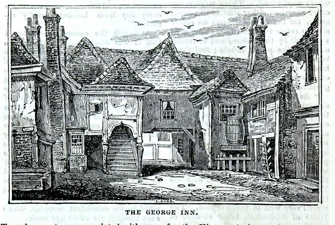
It should be noted that the period use of the name (the Crown Inn) for the Treaty House should not be confused with the “Crown Inn” of the 1600’s. This earlier Crown Inn was located in the center of town near the “George Inn”.
1831 Depiction of the “George Inn” in the center of Uxbridge
In 1645, this pair of Uxbridge inns sat somewhat symbolically on opposite sides of the street in the middle of Uxbridge. They served as the separate working headquarters of the royalist and parliamentary negotiation teams. Although it hosted the negotiations themselves, the Treaty House was a private residence at the time. It seems only a few especially important guests actually stayed there while the negotiations took place. The commissioners (of both sides) were quartered all over town, gathering at their respective inns to meet with their colleagues when the negotiations were not in session.
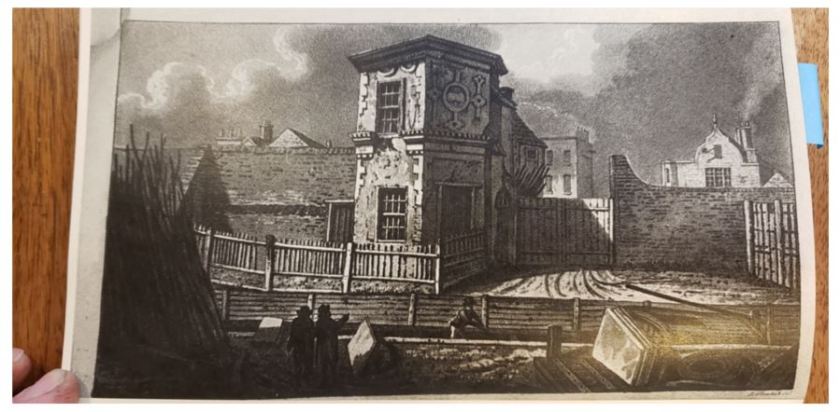
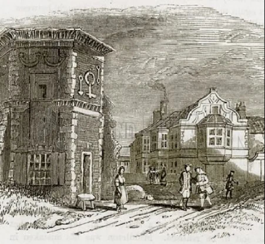
The next image worth discussing is of the Gatehouse (from Riches/Redford book, inserted at pp 64). This ornate and long-vanished gatehouse is believed to have been a remnant of what was originally an enclosing wall around the original Treaty House property. There are several surviving images of this fascinating scene that were clearly made at different times.
This gatehouse drawing from the Riches/Redford book is a great illustration of an important point. Drawings are not direct, objective evidence in the way that photographs are. They are graphical evidence which must be considered for validity.
In this particular depiction, Treaty House in the distance is geometrically flawed, and therefore potentially inaccurate, in my opinion. For example, notice that the angle of the metal sign structure and the angle of the roofine are both depicted seeming to move to the right as they get further away, while the chimney line is depicted angling to the left as it gets further away. Also, the shape of the end face of the building is odd (and inconsistent with other depictions in this, or any other era). One detail that does seem credible is the disappearance of the elegant second floor bay window that once protruded over the Oxford Road.
To its credit, this image clearly explains something that is murky in earlier images this one was apparently based on–a foreground boat canal laid in what was (in earlier times) the bed of the original High Road as it ran around the Treaty House grounds. This is consistent with other records from the first decades after the Grand Canal was finished. By that time, the original property had been split and the Oxford Road had been diverted to pass directly in front of the end of the Treaty House (as it does today). After the Grand Canal was finished, a patchwork of minor “branch” canals were dug to allow canal barge cargoes to be unloaded directly in front of the many industrial buildings which had sprung up in the area. This part of Uxbridge had become an industrial center taking advantage of the place the region’s best water transport (the Grand Canal) and the best road transport (the Oxford Road) intersected.
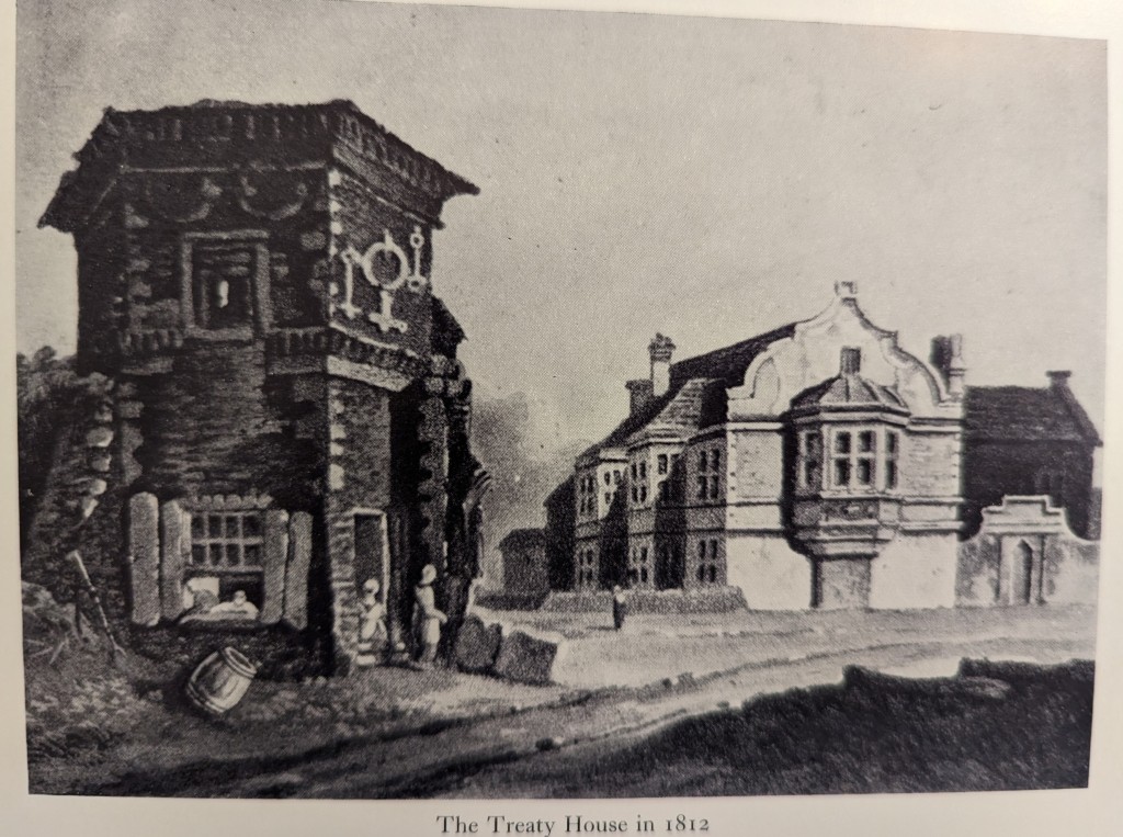
The next image is well done, and unique. This perspective provides a clear view of the second story bay window and many ornate flourishes that seem shared by the gatehouse and the Treaty House (which were originally part of the same property).
Drawing of the Treaty House as it was in 1812 (from the Victoria History of the County of Middlesex, Vol. IV.)
The fragment of wall on the right side of the gatehouse includes the vestige of a large arch rising from it. This probable fragment of a gate and the significant structure to the left of the gatehouse are evidence of a wall surrounding the original property. This makes sense. Such a wall would have been especially important for a property that lay alongside a major roadway.
This image is striking for capturing a number of ornate construction details which disappeared in later, more pragmatic periods of the building’s existence. This primarily includes the dormers above the bay window columns on the long side of the building, the elaborate plasterwork and graceful second floor bay window on the face overlooking the Oxford Road. While this wall was not original, both style and materials from the original house were likely incorporated when this wall was created to repair the severed end of the building.
I was particularly intrigued by the large structure that appears to be appended to the chimney wall of the Treaty House. This particular auxiliary structure is unique to this image. I have to admit this structure sent me on a significant tangent. Studying it, I wondered if the original image might have been from the middle 1700s and might have depicted the original form of the Treaty House. To evaluate this possibility, I created a conceptual model of the original building built upon that possibility. This model turned out to align with nearly all of the criteria from evidence I had gathered. Nearly all. Like Edison’s famous failed attempts to develop a light bulb, it was this failed model that let me to the correct one. In my next article, I will share these models and the form of the original Treaty House they revealed!
The Treaty House in the latter 1700s
A 1796 woodcut of the Treaty House from the Colne river crossing.
Moving into the late 1700’s, there are only a few images available. The first is an excellent woodcut made from the perspective of someone on the far bank of the Colne looking back at the Treaty House. The presence of the bridge over the Grand Canal (which was finished in 1793), is consistent with the reported date of this image (1796). Looking closely at the left end of the building, you can see a second story bay window protruding out over the high road. On the right, note the absence of the hexagonal structure that later appears (and is present today) at that that end of the building.
There are two final images that seem to be the oldest surviving images of the Treaty House. Both depictions are from a perspective looking at the windowed face of the existing building. Both show the Treaty House with a brick exterior, which would place them before the first stuccoing of the building as it appears in the 1796 image above.
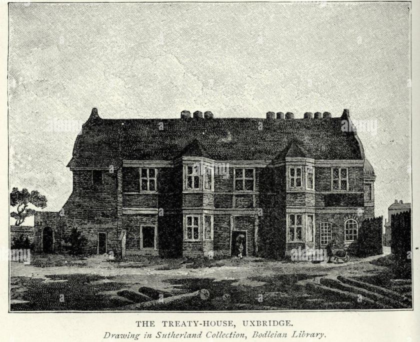
Image of the Treaty House from the Sutherland Collection in the Bodleian Archives at Oxford. Thi image appears to show the building ca 1770’s-1780’s. Photo credit Alamy.
The first of these images is an excellent depiction which I believe shows the Treaty House as in the decades after the main house and other wing were demolished, and before significant repairs eliminated many early details. This image (above) seems to show the house is a state of some neglect and hastily made repairs in the latter 1700’s. I will discuss this image in more detail in my next article, as it provides some surprising insights into the original form of the house–before significant repair and changes around the turn of the century and the 1802 remodel.
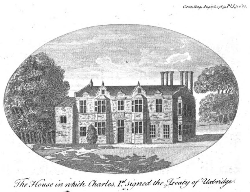
The other of these earliest images is an enigma. This depiction was not made from direct observation, as it has a number of glaring technical flaws no artist capable of producing the image would have made had they been looking at the building while making it. This image appeared in a reader contribution section of the August 1789 edition of the Gentlemen’s Magazine. I’d seen this image before, but had discounted it because of the glaring issues with the depiction.
Drawing of the Treaty House from an August 1789 issue of the “Gentlemen’s Magazine”. With several obvious flaws, it was not made from direct observation, but may have originally been a proposal/concept drawing of what the house would look like after it was salvaged from the demolition of the rest of the house.
The roof is clearly”flattened”, and the chimney configurations are completely wrong–only two of three sets of flues are shown, and they are not in the right locations. Because flues rise straight up from the fireplaces they serve, this configuration would have left much of the house unheated. The bay colum on the right face of the building is also a bit odd, with the depiction of that face seeming wider than the building actually is.
The other end of the building is completely wrong, also. What I think of as the “kitchen” end of the building is integrated under the roof in every other depiction, with an enlarged footprint that provides strength to that end of the building. In this flawed drawing, it appears as a nearly detached structure. Even the caption of this image is very much in error. Not only was no peace agreement reached during these negotiations (after nearly a month of negotiations the treaty was abandoned), but the king was never in attendance. In fact, there is no record indicating King Charles I ever set foot in the Treaty House.
What stymied me is why this image was made in the first place? The fact that it appeared in the 1789 edition of the magazine only establishes that the image existed by that time. It could have been in existence for many years and randomly submitted by whoever possessed it in 1789. And I think it was. The historical errors in the note published with the image suggest it was contributed by someone with limited historical knowledge.
After wrestling with this odd “splinter” under my nail, a scenario finally occurred to me that could reasonably explain the origin of this image. It is my theory that this was a “concept” drawing for what the Treaty House might look like after this still-existing wing was salvaged from the demolition of the rest of the house. Imagine a middle 1700’s developer meeting to discuss their proposal for the work, and providing a drawing to substantiate that the wing could be successfully converted into a coherent, stand-alone building. In this scenario, the exact details wouldn’t have been important. The artist could have reasonably sketched out the details of this wing before going back to a more convenient workplace to produce the final drawing. It also explains the idyllic, park-like setting around the depicted building.
If this theory is correct, then the unique depiction of the original door in the middle of the wing should be at least roughly correct. The stylized gables above the bay columns are unique among images of the Treaty House, but are consistent with other architecture from this period that featured such gables. Of course, these gables are not present in the latter 1700’s image, suggesting that the roof was redone and simplified either as part of the salvaging of this wing during the demolition or sometime in the decades after. Other information substantiates that the full height bay column on the Oxford Road end of this building was implemented after the demolition. This bay column was later amended to remove its lower half, possibly during the 1802 remodel. The the pair of windows on the ground floor at the right end of this wing seem to have been an original feature of the building, even though they seem to have been corrupted by piecemeal repairs by the time the “dilapidated” image was made in the latter 1700’s.
In the next article, I will be introducing the painstakingly produced reconstruction image of the original Treaty House!
I never intended to “take the Pandemic off” from writing, but it certainly worked out that way. I suppose most of us have had our priorities reworked by the historical dramas unfolding around us, so perhaps you understand. In that sense, I do hope this article finds you well!
Probably the most important of the diversions which have otherwise occupied my time is that Mary and I were married in February of 2021 in a classic “turning lemons into lemonade” story…
We were months away from a planned April wedding when new pandemic restrictions threw those plans into the ditch. So we made up a mischievous “Plan B” and married ourselves alone at the Summit of a 12,000 foot high Colorado mountain in February.
With the temperature reaching a high of only 5 degrees (F) and snow blowing around us, I set up a camera tripod with “snow feet” to capture the moment. Using the flowers as a wind screen, I had nestled a lapel microphone deep in the bouquet so the wind wouldn’t drown out our voices. We had tied our rings to our wrists with loops of satin ribbon so we wouldn’t lose them in the deep snow if they were dropped by numb fingers. Finally, I attached three cameras to the tripod because we had agreed there would be no “second takes”–we would either have the the video afterwards, or we wouldn’t. It was a good thing we did this because we later discovered that two of the three cameras had failed in the cold!
So in the end, our wedding was beautiful, exhilarating and achingly romantic. We were both on the verge of frostbite on our hands by the time we got our skis back on, but we didn’t care.
The fun part is that we didn’t tell anyone about it. They found out when we lowered a large video screen in the middle of our September “wedding” some seven months later. We giggled ourselves to sleep many nights preparing to drop that “bomb” on two hundred of our closest family and friends! It went over wonderfully. To paraphrase that great English philosopher (Monty Python, of course), ” We’re not dead yet!”.
Life is short. Whatever you’re going to do, either get on with it or be ready to accept that perhaps you never will.
The backhanded power of mortality is the focus it gives you. When you’ve only got so many breaths to take, it becomes far more important how you spend them. For most of my life, I’ve felt the presence of a rocking chair somewhere in my future–waiting for me. When I get to the point where the best I can do is collapse into it and enjoy the company of those I’ve shared my time with, I don’t want to look back and wish I’d been bolder about how I’ve lived my life.
Although its been months since I’ve published an article, it definitely wasn’t because I ran out of material! In fact, there are several articles that have been sitting nearly complete for months. What’s occupied my time is making an important “gut check” about my commitment to a personal matra that’s been growing in importance in my thoughts:
Life is short. Whatever you’re going to do, either get on with it or be ready to accept that perhaps you never will.
So, I’ve decided its time to get on with it.
For the last three months, I’ve been busy rewriting the trajectory of my life. My houseful of possessions has been cut down by much more than half. And the house? Someone new owns it and lives there now. I’ve subsequently paid off all my bills. I’ve changed to a new job. And the woman I’ve ridden across the state of Iowa with, and ridden through the 5 boroughs of New York City with, and climbed two of Colorado’s 14,000+ foot high mountains with this year? Last weekend, I asked her to marry me (and, for a surprisingly small bribe, she even agreed!).
Mary and I atop Torrey’s Peak, one of Colorado’s 14,000+ foot high mountains.
But that’s only where it starts. I am saving all I can now, because I have decided to find a way to retire in the not-too-distant future, and do some things I yearn to do while I’m still physically able.
In short, we are trading our housefuls of stuff (and the houses) for the chance to see the world from the seat of a bicycle and from the working end of trekking poles. Although we are still about two years from actually boarding the plane, we are preparing to largely uproot ourselves and live overseas for as much as five years. It takes my breath away to think of it.
This conversation began with how we might be able live in England long enough to finish the research necessary to complete my book on the “Lost Lord Keeper”. Although my last trip to the UK was wonderful, I was jet lagged half the time, and there was a surprisingly long list of things that simply couldn’t be packed into a two week visit. To get this done is really going to require living there.
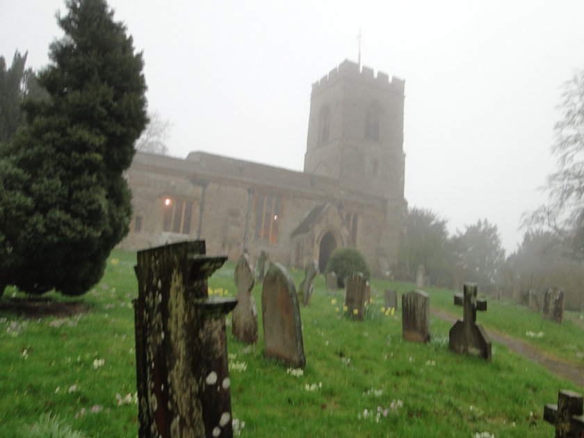
It was a chilly day of drizzle when we visited the Church of St. Peter and St. Paul in Courteenhall, England (Sir Richard Lane’s boyhood home, and home to the tomb of his parents)
So we sorted out what it would take, and the changes we’d have to make to pull it off. It required some sobering sacrifices…but it was doable. Once we got our heads around that much, we realized there was no reason to stop there. Once we could accept being uprooted for awhile, why not live for a season or two in all the interesting places we’ve longed to see? If we are able to find affordable but well connected places in which to make a temporary home, we could make day trips to all the nearby places we’d love to spend time in. What would it be like if we were able to live in each place long enough to really explore, to make friends, to learn some local cooking, to find some great local pubs, and to learn some basic fluency in the language? While there, we could bike and hike our way to countless quiet places we could only rush past any other way.
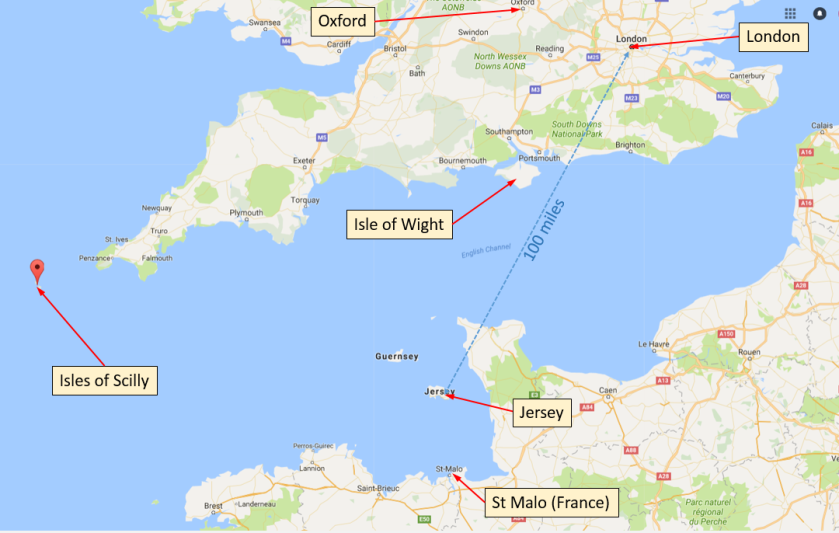
Map of key sites of interest in the Richard Lane story in southern England, Jersey and France.
Our initial plans for a post-England “world tour” will likely include successive months-long stays in Czechoslovakia, France, Spain, Italy, Thailand, Australia, Paraguay and Panama. While in each of these places, we hope to make many short trips to visit all around each region. All the while, I can write from wherever I am, and especially if we are still in Western Europe, it would be easy enough to “pop over” to the UK should I need to follow up on research (or visit friends). Who knows, I might even find my next research project somewhere along the way…
The hard part about this plan is being away from places we know as home, and those we love. Thankfully, we live in a time in which technology has made it easier than ever to remain in meaningful touch with those you care about while you are away from them. But we also plan to fly home for a couple of months at least once a year so we can spend real time with the friends and family we have been blessed with.
And this is where a really intriguing possibility occurred to us: while we are overseas, why not invite our friends and family to come spend time with us? All we have to do is rent a flat with an extra bedroom and (with a little coordination) we can host them and share the magic of wherever we are with them too—with their housing, meals and transportation taken care of.
And at the end of it all, when we finally return home? We will absolutely invite our new overseas friends to come stay with us in America. How fun would it be to repay hospitality by sharing the magic of Colorado with friends who might never see it any other way?
Basic means aside, all of this only requires that we be willing to live more simply, and to travel light.
No doubt, there will be challenges. But I have a great partner and cohort to solve them with. And, if we are somehow able to do (and share) all this, we might just giggle ourselves to sleep in those rocking chairs!
So, with apologies about being “offline” for so long, please stay tuned! I’m settled into my new job. The heavy lifting of selling my house and moving is over. All of my research materials have finally been found and unpacked. Shortly, I will be back into my writing rhythm again!
So what’s next?
Up next is an entirely new topic—an interesting set of articles looking into Richard Lane’s experiences as one of the King’s Commissioners in the 1645 Peace Treaty Negotiations at the “Crown and Treaty” in Uxbridge. If you google “Crown and Treaty Uxbridge” you will find Wikipedia has a good overview article about this beautiful venue and the peace negotiations that were held there nearly 400 years ago.
The 500-year-old Crown and Treaty, Uxbridge. Photo credit Wikipedia.
I’m looking forward to local reactions in Uxbridge regarding the novel reconstruction I’ve done of this historic site. Drawing on various bits of historical evidence and the timeless practicalities of civil design, I’ve managed a reconstruction includes not only the structure of the original building and its long vanished grounds, but also a significant portion of its original interior. Included in this reconstruction is the very room that was once packed with the “commissioners” as they tried desperately to find a way to stop the Civil War (spoiler alert: Unfortunately, I’ve determined this room no longer exists). This was a challenge…although I’ve visited the Crown and Treaty, it was between owners and locked up at the time. I’ve never been inside…
Note: I just noticed that the Crown and Treaty has recently been re-opened (and looks wonderful–can’t wait to have dinner there someday!). There are now lots of interior pictures which were not available when I did my reconstruction. It will be fun to match them up with my model to see how I did working in the blind!
This article regards the surprising trajectory of London–one of the world’s great cities, and an international treasure that once suffered a calamitous decline, and spent many decades as an abandoned ruin.
With apologies for being offline for so long, this is the first of four articles that all grew out of what I expected to be a single, quick article about our visit to the “Crown and Treaty” in the outer London town of Uxbridge. Built in the 1500’s as an elaborate private home, this fascinating building still stands, and was the home of the 1645 Uxbridge Treaty Negotiations. In what has become the usual fashion for me, more thoughtful reading of accounts about the negotiations and Sir Richard Lane’s role brought me to details that struck me as unexpected and intriguing–off-topic “threads” hanging from the edges of the story. Such are the entrances of “rabbit holes” from which I have dragged more surprising insights than I’d ever have thought possible. This particular one is about the surprising trajectory of London–one of the world’s great cities, and an international treasure that once suffered a calamitous decline, and spent many decades as an abandoned ruin.
Foreword: This is the full article submitted for publication in the 2018 Annual Bulletin of the Société Jersisiase. This version includes significant additional content which could not appear in that publication, and benefits from the excellent editorial refinements of the editors at the Société Jersisiase. In this format, footnotes appear the end of the sections in which their references occur.
In this second part of the article submitted for publication in the 2018 Annual Bulletin of the Société Jersiaise, Richard Lane rises quickly in the king’s service amid dire circumstances in the wartime capitol of Oxford.
This conclusion of the article submitted for publication in the 2018 Annual Bulletin of the Société Jersisiase chronicles the last few weeks of Richard Lane’s life in the Elizabeth Castle, and his dramatic 1650 burial in St Helier, Jersey.
In the Part I article of the “Trial of Strafford” analysis I presented at Westminster this Spring, I provided an overview introducing the historical analysis I did and the groups depicted in that historic painting. In this and the next article, we’re going to explore the depth of the stories painter Thomas Woolnoth laid onto that sprawling canvas in the early 1840’s.
In our time, Woolnoth would have been the videographer behind a BBC historical docu-drama of this pivotal event in English history. But in the early 1840’s even the earliest deguerrotype camera was a technical oddity, leaving Woolnoth only the brush and palette to carry his audience back to the floor of Westminster Hall in the spring of 1641. Continue reading “Westminster Palace: Analysis of the 1844 Trial of Strafford Painting (Part 2)”
My apologies if I seemed to have gone “offline” for a few weeks. It’s taken quite a bit of sorting to be sure nothing got lost from the trip to the UK. I also took time for a badly needed camping and mountain biking trip to Moab (which in turn cost me a bit more time to heal from a crash I had on one of those truly fabulous trails)!
I’ve been keen to share the presentation I gave at Westminster, but struggled mightily to get it into a single article. Having failed that, this will be the first of three in which I will take you through the analysis I shared with the Office of the Curator of the Parliamentary Art Collection last month. This analysis regards the “Trial of Strafford” painting that hangs in the House of Lords side of the parliamentary complex at Westminster, London. Continue reading “Westminster Palace: Analysis of the 1844 Trial of Strafford Painting (Part 1)”